Big city

Low Rise by Peter Root

Low Rise by Peter Root
Pictorial Webster’s: Inspiration to Completion from John Carrera on Vimeo
‘as a source for creativity in the human brain’
Yesterday, I thumbed thru Chronicle Books’ trade edition of Johnny Carrera’s Pictorial Webster’s: A Visual Dictionary of Curiosities. The video (above) details the inspiration for the project, historical cataloging, Linotype setting, as well as the design and hand binding of the fine press editions.
More detailed details are posted here. Also, check out the very Victorian Wall Cards and Stamp Set.
Carrera is the proprietor of Quercus Press, based in Waltham, Massachusetts.

Click on image to jump/view larger version
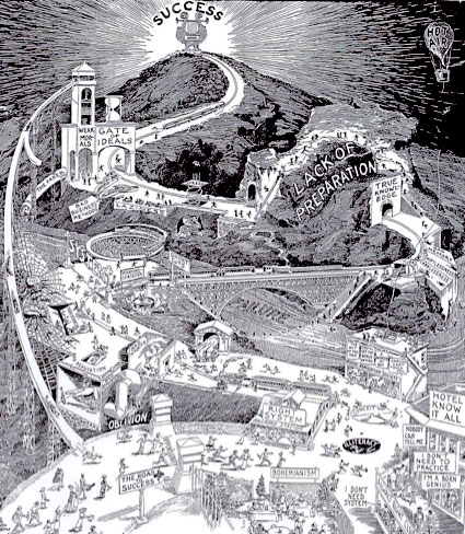
Hm. Starting to see problems with approaching life as a bohemian.
Found via Strange Maps
I used to count ‘graphic design’ as one of the Seven Deadly Sins – I had it listed among the sins on an old business card (replacing ‘gluttony,’ of course).
Kansas State University Geography students have visualized the sins as regional, at least in the US. View the maps here.
Found via One Floor Up
Maps of War’s History of Religion
Student work from Sweden: Tomas Nilsson reinterprets Little Red Riding Hood (above). Music by Slagsmålsklubben. You know, I never did understand why the wolf – with the big ol’ teeth – never actually chewed his food.
Nilsson’s animation was inspired by Röyksopps’ Remind Me (below).
Found via Twitter.com/grain edit
If you’re wondering why Type Daily says ‘since 1455’ up top . . . this historical atlas will fill in some of the blanks.
After Johann Gutenberg did his thing, the technology of printing spread across Europe in just around 50 years.
This interactive map from the University of Iowa charts its progress – with timeline, zoom features, trade routes, locations of paper mills and more. Also included is a briefly animated model of what we know of Gutenberg’s press.